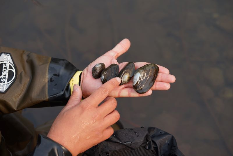
North America’s nearly 300 species of freshwater mussels are keystone species in rivers, streams, and lakes. These ecosystem engineers clean and purify water, create habitat and food for other wildlife, and concentrate nutrients. When a waterbody has mussel beds, fish populations grow faster and better survive periods of drought or disease. In short, freshwater mussels keep our aquatic ecosystems healthy. They are also part of a long cultural tradition in North America, serving as important sources of food or materials for trade.
Yet freshwater mussels are among North America’s most imperiled wildlife. Over 70% of species are in decline, of which 10% are extinct, 21% are listed as endangered, and another 40% are listed as threatened. Since these mostly still and silent animals live for decades below the water’s surface, they are at great risk of being forgotten when we go about planning new bridges or shipping routes, stream habitat restoration, water withdrawals, or the many other ways we use our watersheds.
That’s why the Xerces Society began working on freshwater mussel conservation more than 15 years ago, conducting outreach, research, monitoring, and developing resources like guidelines to protect mussels during instream work and a new survey protocol. This spring of 2025, Xerces and our partners reached a major milestone by launching the Western Mussel Atlas, which will help bring these critically important animals into the conversation about how we manage healthy waterways.
Why focus on western mussels?
As North America became more developed and industrialized, freshwater mussels east of the Continental Divide were heavily overharvested by collectors and for the natural pearl and button industries. West of this line, mussels mostly escaped overharvest and, so far, have avoided the widespread introduction of nonnative bivalves like zebra and quagga mussels, which led to further population declines in eastern states beginning in the 1980s. In spite of this, western mussels have faced major threats, such as the draining or diversion of waterways and habitat destruction from logging, straightening, or “cleaning” streams. As a result, our relatively few western species (floaters, western pearlshell, and western ridged mussel) have quietly declined in abundance and distribution.
How to Use the Western Mussel Atlas
You may already be familiar with atlas projects at Xerces, including our Bumblebee Atlas, Western Monarch Count, and Firefly Atlas. The Western Mussel Atlas, like these projects, is a way to locate and protect these overlooked and undervalued species. It was created as part of a larger, collaborative effort between Xerces and our partners at the U.S. Fish and Wildlife Service, Oregon Department of Fish and Wildlife, Washington Department of Fish and Wildlife, and Confederated Tribes of the Umatilla Indian Reservation. The Western Mussel Atlas has several key aspects that are useful for both mussel enthusiasts and professional biologists.
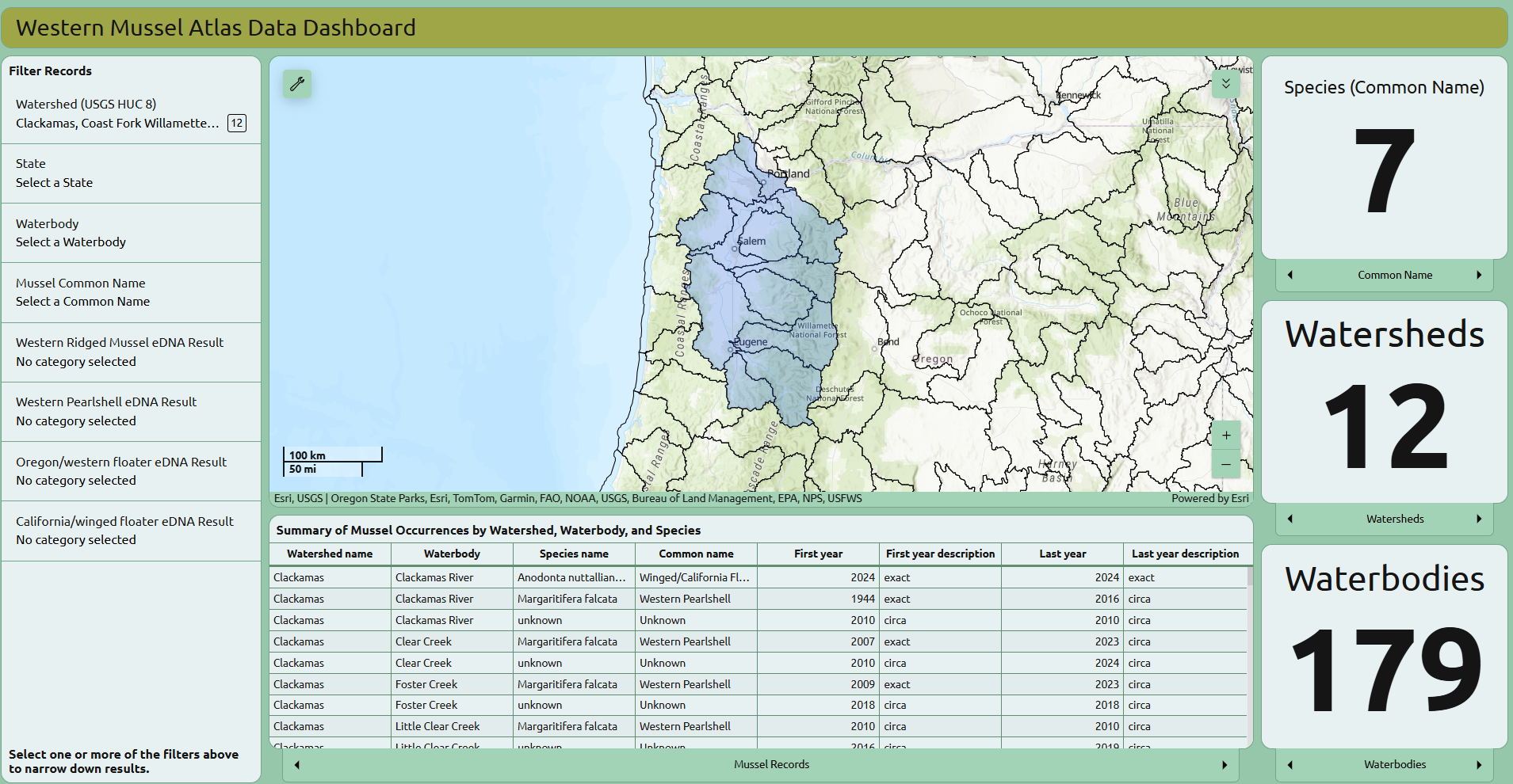
Explore Your Watershed with the Data Dashboard
Do you know what lives in your waterways? The data dashboard enables users to filter the map by watershed to learn more about which lakes, rivers, and streams are known to have (or once had) each of our different mussel species. Knowing where mussels occur is the key first step to understanding whether they could be impacted by human activities in streams.
The data dashboard reflects the contributions of many individuals and organizations whose observations have improved our collective understanding of mussel distribution. We have also developed an easy-to-fill-out survey form to share your own observations of mussels or their shells, whether you are a biologist or not, whose data will be added to our dataset and updated in our dashboard.
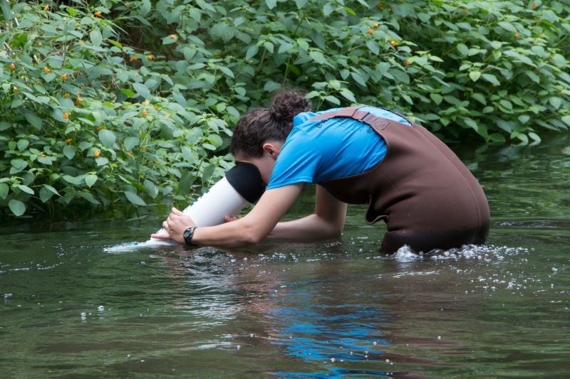
Contribute to Mussel Research with the Survey Protocol and Data Portal
For professionals looking to share or access research-grade data, we have developed a survey protocol that describes how to perform standardized surveys for mussels so that we can begin to collect data for locations where mussels are either observed or, importantly, searched for but not found. “Absence” data is a valuable but often overlooked aspect of species distribution information.
Our survey methods and data portal are set up to collect all manner of detailed data, including where mussels do or don’t occur, how big their populations are, and whether they are healthy, reproducing mussel beds or not.
Unlike our other Atlas projects, we are not recruiting community scientists to conduct mussel surveys. This is because underwater surveys can be dangerous and require careful safety protocols.
Seeing Below the Surface
In 2016, Xerces staff worked with the IUCN Red List to evaluate the extinction risk of our western mussel species. At the time, we had only limited information on where mussels had recently been observed, compared to where they had historically been found. Without the tools and resources to support surveys for freshwater mussels, these species remained below the surface and out of sight. Over time, we have worked with our partners to find ways to advance mussel conservation in western North America, and the Western Mussel Atlas has grown from these efforts.
With the kind of data gathered and standardized through the Western Mussel Atlas, we will be able to better understand the status and trends of these species over time. This kind of information is critical to help us identify which populations are in greatest need of our support and protection. For species like the western ridged mussel, which is being considered for federal endangered species listing, we are in desperate need of more information.
Special thanks to our partners at USFWS, ODFW, WDFW, CTUIR, USFS, and BLM. Partial funding for this project has been provided by the US Fish and Wildlife Service through the Oregon Department of Fish and Wildlife, under Federal Award Number AF22AP03265-00 and through the generous donations of Anthony and Doug Gordon.
Learn more
- Western Mussel Atlas
- Learn more about western freshwater mussel conservation
- Confederated Tribes of the Umatilla Indian Reservation’s freshwater mussel program
- Pacific Northwest Freshwater Mussel Workgroup
- Freshwater Mollusk Conservation Society
Emilie holds a master's of science in biology from Kansas State University and a bachelor's degree in biology from Berea College. Her professional experience includes more than 10 years working in biological research, conservation, and restoration. Her recent work ranges widely, from surveying for high alpine stoneflies, to snorkeling rivers to observe freshwater mussel populations. In her current role, Emilie also serves as the lead on freshwater mussel conservation work at Xerces.